Pen y Gaer Hill Fort
Pen y Gaer Hill Fort


Sophisticated Iron Age defences and resistance to Roman rule
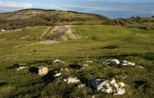
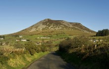
Believed to date to the late Bronze Age or early Iron Age, the hill fort at Pen y Gaer has some interesting strategies for defence. Where the hill is steepest a single rampart was constructed, but against the gentler slopes, three ramparts were built. The inner rampart consisted of a dry-stone wall filled with rubble, while the outer defences were banks of earth and rubble. When excavated in the early 20th century, the area beyond these ramparts was found to be the site of a so-called ‘chevaux de frise’ – a large expanse of uneven stones and boulders designed to hamper the efforts of any would-be attackers. This type of defensive structure is rarely found in Britain.
Within the enclosure were traces of around a dozen roundhouses. The lack of stonework at these sites suggests they were constructed in wood. Artefacts recovered were few, but those that were found revealed evidence of iron working. Rubbing stones, a stone spindle whorl and sling stones were also found. There is no evidence of occupation after the Roman conquest, and it has been speculated that the fort may have fallen victim to the onslaught of the Roman legions as they pushed through this part of Gwynedd. A large garrison was eventually stationed at Caerhun, slightly lower down the Conwy Valley, suggesting that the area generally was the scene of fierce resistance by local tribes. It seems probable that the Pen y Gaer hill fort would have featured prominently in this resistance.
Links
Archwilio- Accessible by Public Transport
- Parking
- Good Walks Nearby
- Family Walk
- Viewpoint
Directions
By Road
Follow B5106 south of Conwy. Turn right at Tal-y-Bont for Llanbedr y Cennin. Follow road uphill for approx 1/2 mile then take sharp left. Limited parking.
By Rail
Conwy - 6 miles
By Bus
Tal-y-Bont - 2 miles
By Bike
Cycle route Conwy to Betws y Coed
Walking
Footpath to hillfort. Easy access. Moderate 5-minute walk from carpark.
Access Details
Walking boots recommended. OS map required. Dogs must be on lead.
Practical Details
Full Figure Grid Reference: SH 750693 OS Landranger map sheet: 115
Contact
- Address
- Pen y Gaer Hill Fort, Llanbedr y Cennin