Prehistoric and medieval landscape and field systems
Prehistoric and medieval landscape and field systems


Medieval fields and long huts
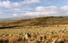
The steep-sided valley of Ceunant Egryn, nestled beneath the Iron Age hill fort of Pen y Dinas, is home to one of Britain’s most impressive and well-preserved ancient landscapes. Aside from the hillfort itself, the surrounding land is home to prehistoric settlements, a stone quarry used during the building of Harlech Castle and medieval farming settlements with their characteristic ‘long huts’.
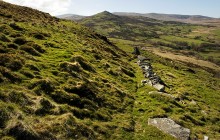
The prehistoric settlements are believed to be Iron Age farmsteads, built at roughly the same time as the hill fort. They are laid out as concentric circles of banks and ditches around a central enclosure of huts. Much of the ancient field system has been obscured by the later, medieval settlements when population expansion forced people to occupy what was, by then, marginal land. What they have left is a largely undisturbed medieval system of irregular fields bordered by walls of stone, plus a number of enclosures containing two or three ‘long huts’.
Many of these huts are themselves divided into two or three separate rooms, but there is no standard layout. Some walls remain, but the majority of the stone here has been plundered for use elsewhere. It is thought that the medieval farmsteads may have been affiliated with the nearby Egryn Abbey.
- Accessible by Public Transport
- Good Walks Nearby
Directions
By Road
Site is near Egryn Abbey (National Trust) between Tal-y-Bont and Llanaber and is on A496 Harlech to Barmouth road. Parking on road at Capel Egryn.
By Rail
Nearest Station Harlech - 7 1/2 miles Tal-y-Bont stop - 1 mile
By Bus
Tal-y-Bont, Capel Egryn bus stop
By Bike
On-road cycle route, Route 8 Lôn Las Cymru A496
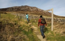
Walking
Follow track / path from Egryn Abbey uphill. This is the same path to Carneddau Hengwm burial chambers. Landscape mostly on your left halfway up the hill between 120 and 240m above sea level and each side of track as slope levels out.
Access Details
This is a good walk (approx. 45 minutes) uphill on a mountain path. Walking boots and suitable clothing recommended. Dogs should be on lead. This is accessible with Public Transport to start point of the walk at Egryn. OS map essential.
Practical Details
Full Figure Grid Reference: SH 605204 OS Landranger map sheet: 124
Contact
- Address
- Prehistoric and medieval landscape and field systems, Egryn