Pen y Dinas Iron Age Hill Fort
Pen y Dinas Iron Age Hill Fort

An echo of a local stronghold
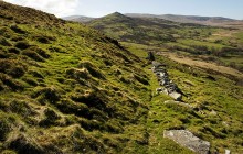
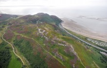
The Iron Age hill fort at Pen y Dinas, though strongly defended on three sides by steep natural cliffs and a massive wall and ditch, is thought to have been only a local stronghold. It lacked the credentials to dominate the surrounding landscape in the manner of the major hill forts of the day. Pen y Dinas hill fort lies at the north side of the small, deep valley of the River Egryn, which would have provided a ready water supply. It is believed that the majority of British hill forts are roughly contemporary, dating from sometime between 1500–1000 BC. Subject to regular reconstructions, many of these strongholds were in use up to the post-Roman/early medieval period.
Pen y Dinas is significant to the study of archaeology – in 1919 O.G.S. Crawford, one of the most renowned field archaeologists of the 20th century, conducted his first survey project here. His excavations showed that the defences had two phases of construction, but there were no datable finds. The lack of pottery from the Roman period suggests the fort was not used after the Roman occupation.
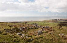
Outside the fort a complex of grassed-over earthworks are the remains of a medieval village.
These consist of the platforms of rectangular houses, yards, tracks and fields, which even retain evidence of medieval cultivation. One of these fields cuts across the entrance track into the Iron Age fort, showing that Pen y Dinas had gone out of use by that time. However, the hill fort may have retained some status as an ancient territorial centre, attracting settlement to it.
Links
Archwilio- Accessible by Public Transport
- Good Walks Nearby
Directions
By Road
Site is near Egryn Abbey (National Trust) between Tal-y-Bont and Llanaber and is on A496 Harlech to Barmouth road. Parking on road at Capel Egryn.
By Rail
Nearest Station Harlech - 7 1/2 miles Tal-y-Bont stop - 1 mile
By Bus
Tal-y-Bont, Capel Egryn bus stop
By Bike
On-road cycle route Route 8 Lôn Las Cymru A496
Walking
Pen y Dinas is on the north side of Ceunant Egryn and is best approached up trackway from Hengwm Farm. 45 minute walk each way.
Access Details
This is a good walk (approx. 45 minutes) uphill on a mountain path. Walking boots and suitable clothing recommended. Dogs should be on lead. This is accessible with Public Transport to start point of the walk at Egryn. OS map essential.
Practical Details
Full Figure Grid Reference: SH 6606208 OS Landranger map sheet: 124
Contact
- Address
- Pen y Dinas Iron Age Hill Fort, Egryn