Muriau’r Gwyddelod (the Walls of the Irish)
Muriau’r Gwyddelod (the Walls of the Irish)


Iron Age farming life
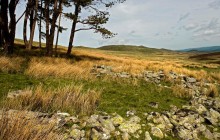
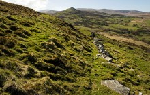
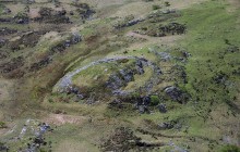
Muriau’r Gwyddelod, meaning ‘the walls of the Irish’, is an exceptionally well-preserved Iron Age farming landscape above Harlech, complete with the remains of roundhouses, stone-walled enclosures and ancient field boundaries. The site comprises two courtyards, built close to one another and surrounded by a sub-circular stone enclosure, around which radiates a system of so-called ‘Celtic fields’.
The north-eastern courtyard contains the remains of three stone-built roundhouses, while that to the south-west appears to have contained only one. A little further off there is another large, roughly circular enclosure, also stone-walled, which may once have contained another settlement. Old maps of the area suggest that the name Muriau’r Gwyddelod was given originally to this site rather than to the courtyard settlements.
The site is close to the north-eastern end of the ancient trackway known locally as Y FforddWyddelig, or the ‘Irish Way’, and it is thought probable that Muriau’r Gwyddelod was its destination. The site is around 700 metres long, though aerial photographs have revealed that the ancient field system extended much further. The field boundaries are visible for the most part as tumbled lines of stones, but it is thought that certain modern fields in the area, many of which feature irregular walls, may preserve the ancient field pattern. The so-called ‘Celtic fields’ are distinguished by their rectangular shape, while later medieval fields tend to be long, thin strips of land. Other similar sites nearby attest to the fact that the whole area must have been developed for farming in ancient times.
Links
Archwilio- Accessible by Public Transport
- Good Walks Nearby
Directions
By Road
Enclosures and hut circles are just off small road from Harlech to Llanfair
By Rail
Harlech - 1/2 mile
By Bus
Harlech bus stop
Walking
1/2 mile south of castle. Footpaths nearby.
Access Details
OS map required
Practical Details
Full Figure Grid Reference: SH 582303 OS Landranger map sheet: 124
Contact
- Address
- Muriau'r Gwyddelod, Harlech